Map

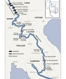
Mekong Mainstream Dams Map

Wednesday, June 28, 2017
Updated, June 2017 Download the Mekong mainstream dams map (PDF, JPEG)

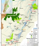
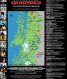
Maps Project- Potential Flooded Areas of Dams in the Magdalena River

Monday, November 9, 2015
Potential Flooded Areas of Dams in the Magdalena River by International Rivers Explanations of Maps and Analysis Prepared by: Charles Wight[1] Of the many human-induced impacts facing rivers today, the construction of large hydroelectric dams disproportionally affects the tropics (World Commission on Dams 2000, Brandt 2000, McCully 2001). While dams are actually being removed in the global north, construction in the tropics is booming (McCully 2001, AmericanRivers.org). The Magdalena River is the largest river system in Colombia with a waters

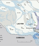
Map of Don Sahong Dam

Don Sahong Dam
Monday, August 18, 2014
Don Sahong Dam International Rivers

New Maps Project Potential Flooded Areas of Dams in the Marañón River basin

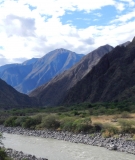
Marañón River canyon
Friday, April 25, 2014
The majestic Marañón River, the source of the Amazon, descends from the high Andean Mountains, picking up waters from dozens of tributaries carving spectacular canyons until it reaches the flatlands of the Amazon. The Peruvian government calls it the country's "energy artery" as it plans to harness the river's hydropower potential by building more than 20 dams on the mainstem Marañón in order to power mining projects and export electricity to Brazil. However, the Marañón River Basin is also a unique ecosystem that supplies the vast majority of the water, sediment, nutrients, and organic

2013 - Day of Action for Rivers

Thursday, March 14, 2013
Check out the 2013 map of actions and stories, send us yours and we will add them! Every year, thousands of people around the world lift their voices on March 14 to celebrate the world's rivers and those who struggle to protect them. By acting together, we demonstrate that these issues are not merely local, but global in scope. We hope that you take action, and tell us all about it.

Map of Dams and Seismicity on the Nu River

Monday, November 12, 2012
GIS map of proposed dams on the Nu and seismicity hot spots.

Map of Dams and Biodiversity on the Nu River

Monday, November 12, 2012
GIS map of proposed dams on the Nu River and the Three Parallel Rivers of Yunnan Protected Areas (a UNESCO World Heritage Site).

Tracking Greenwash - a Map of "Sustainability Partner" HSAP Assessments and Commitments

Wednesday, October 31, 2012
Dam builders have begun to utilize the Hydropower Sustainability Assessment Protocol (HSAP) to assess dam projects around the world. In some cases, dam builders may use the HSAP to give a public relations push to old, non-controversial dams, such as the Trevallyn Power Station operated by HydroTasmania in Australia. In other cases, dam builders may use the HSAP to greenwash particularly destructive dams that are under construction or close to operation, such as the Murum Dam being built by Sarawak Energy Berhad in Malaysia. This map tracks which projects are receiving unofficial or official H

Pages

Subscribe to RSS - Map