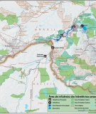
Map

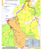
Map of Planned Dams in the Tapajós Basin

Map of planned dams and impacted protected areas in the Tapajós basin

Tapajós Basin Dams

Click here to see a full map of the dams planned in the Tapajós basin
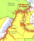
Proposed dams on the Tapajós RiverThree large hydroelectric dams are proposed for the mainstem of the Tapajós River in the state of Pará – São Luiz do Tapajós, Jatobá and Chacorão. Together they would flood a total of 198,400 hectares (ha), including 11,000 ha of the Amazonia and Juruena National Parks and over 23,000 ha of the Itaituba I and II National Forests. These dams would also have significant impacts on several indigenous lands and communities, including the Mundurucu, Apiaká de Pimental, Akaybãe, Remédio, Sai Cinza, São Martinho and Boca do Igarapé Pacu. Proposed dams o

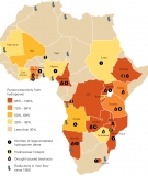
Hydrodependency in Africa: Risky Business

Thursday, September 9, 2010
From September 2010 World Rivers Review The world gets about 20% of its electricity from hydropower, but in Sub-Saharan Africa that number is 60% (excluding coal-heavy South Africa) – and many countries get more than 80% of their electricity from dams. Drought-caused blackouts are common, and expected to get worse with climate change. Hundreds more dams are being planned, many of them in already dangerously hydro-dependent regions. This map shows the current status of hydrodependency across the continent, and plots some key proposed dams in these places. Finally, we include some informati

Map of Climate Change Hotspots

Will A River Still Run Through It? Around the world, climate change is melting glaciers that feed major rivers, contributing to drought-induced hydroelectricity blackouts, and threatening the water supply and river resources of billions of people. As major rivers worldwide experience dramatic changes in flow due to dams, their natural ability to adjust to and absorb disturbances decreases. Rather than being part of the solution, dirty dams are too often a big part of the problem. Here we present a some key climate change impacts that threaten the world’s rivers and the people who depend on

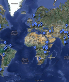
Google Earth Map of Global RIS Sites

Click on the virtual push pins below for more information on known or suspected RIS sites. View Global Suspected RIS Sites in a larger map

15 Key Dam Projects in the Himalayas

Wednesday, December 10, 2008
More on dam building in the HimalayasRead the report: Mountains of Concrete

Map: A Dam Rush on the Mekong?

Friday, June 1, 2007
The Mekong River Basin's diversity and productivity is threatened by plans for scores of dams. This map looks at what's in store and what's at stake for one of the world's great rivers. (from World Rivers Review, June 2007)

Map of Key Existing and Proposed Dams in Laos

Monday, October 29, 2007
Map produced by TERRA based on Maunsell-Lahmeyer International Lao Power System Development Plan (2004), and updated by International Rivers with information from August 2007 Lao Power Development Plan.

Pages

Subscribe to RSS - Map