List of Dam-Threatened World Heritage Sites
The following list describes several World Heritage Sites under threat from existing or proposed dams. This is not meant as a comprehensive list of all dam-affected Sites, but rather a first step towards documenting the global threat that many World Heritage Sites currently face. The first five sites include those where International Rivers or our partners have active campaigns.
Three Parallel Rivers of Yunnan Protected Areas
CHINA

China’s Three Parallel Rivers site in Yunnan is known as the epicenter of Chinese biodiversity. According to UNESCO, this impressive watershed supports more than 6,000 plant species and nearly a quarter of the world’s animal species. The region is also prone to frequent and deadly landslides and earthquakes. This fragile and unique ecosystem, and the communities that depend on it for survival, is threatened by the recently revived proposal to build a 13-dam cascade along the main body of the Nu River in Yunnan Province, which flows through the Three Parallel Rivers World Heritage Site (WHS). The Environmental Impact Assessments for the entire cascade have yet to be released. Dam construction on the three rivers would alter the sediment and water flow into the Three Parallel Rivers World Heritage property and significantly change the scenic and ecological value of the site.
In 2011, civil society groups recommended to the World Heritage Committee that they urge the State Party to halt all dam construction activities around the World Heritage property until the full EIAs for these projects have been published. However, the full EIAs have not been made publicly available. China has maintained its commitment to develop dams on the Nu, Jinsha and Lancang rivers as part of its 12th Five Year Plan. In 2011, Huadian Corporation indicated that the company planned to proceed with the dams during the next five years.
Two trips by International Rivers and the Chinese NGO Green Watershed in 2011 indicate that the northern-most dam, Songta, just above the Three Parallel Rivers WHS, has started site preparation. Photos taken by kayakers in early 2012 show that site preparation also also begun at the Maji dam site. Photos taken by another observer in May 2012 shows that construction activities have continued at the site of the Wunonglong dam site on the Lancang River despite a temporary halt to the work due to a lack of official approval. In addition, a new dam, Upper Tiger Leaping Gorge, is being planned on the Jinsha, which would flood the first bend of the Jinsha River.
Lake Turkana National Parks
KENYA
Lake Turkana – the world's largest desert lake – makes life possible in parched northern Kenya. The lake is home to the world's largest population of Nile crocodiles, healthy populations of hippos, and hundreds of bird and fish species. More than a quarter-million indigenous peoples have become masters of wresting sustenance from this harsh landscape.
Lake Turkana was chosen as a World Heritage site because of its rich ecosystem, whose "diverse bird life and desert environment offers an exceptional laboratory for studies of plant and animal communities." There is strong evidence that the Gibe III Dam, now under construction in Ethiopia, threatens the very characteristics for which Lake Turkana was chosen as a World Heritage Site. The dam will so change the watershed's hydrological regime that the Lake could end up a shrunken, ecologically unsustainable relic, no longer able to support its current diversity of life (including human communities). The dam also threatens the Lower Omo Valley World Heritage Site, home to remarkable cultural diversity and a wealth of archeological treasures dating back 2.4 million years.
Numerous outside experts have described how the dam endangers the lake. For instance, an April 2010 draft study commissioned by the African Development Bank reveals numerous hydrological changes that will impact Lake Turkana. The study's author, Dr. Sean Avery, says that the Gibe III Dam "will inevitably cause flows to the lake to diminish ... Lake Turkana is dependent on the Omo River for almost 90% of its inflow. The river is the lake's umbilical cord. If the Omo River inflow is cut, the lake level will fall..."
In August 2011, the Kenyan parliament passed a resolution asking for the suspension of dam construction pending further studies. However, construction of the Gibe III Dam continues. The project will also likely receive funding from the World Bank for its transmission lines. On June 21, the World Bank is expected to submit to its Board of Directors a credit of US$684 million for a 1,000-kilometer-long transmission line from Ethiopia to Kenya. Strong evidence links this transmission line to the Gibe III Dam. A monitoring mission to Kenya was conducted, but not to Ethiopia.
For more information, visit Friends of Lake Turkana.
Lower Valley of the Omo
ETHIOPIA
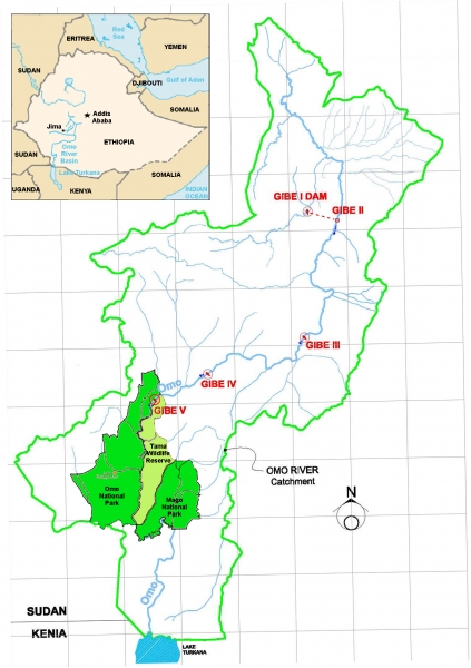
The Omo River is a lifeline for hundreds of thousands of indigenous farmers, herders and fishermen who depend on its nourishing floods to sustain their most reliable sources of food. The national parks of the Lower Omo Valley in Southwest Ethiopia are among “the last unspoiled biodiversity hotspots in Africa” and constitute “resources of all people in the world” according to Ethiopian government officials.
The Gibe III Dam is putting this biodiversity, along with the livelihoods of thousands at risk. The dam will regulate and reduce the Omo River’s flow, increasing hunger and fueling conflict throughout the basin. Recent studies also show that the Gibe III Dam will allow the creation of large sugar plantations and other cash-crop farms that are irrigated with water from the Omo River. The lands that have been designated as sugar plantations have been inhabited by indigenous peoples for thousands of years. Some tribes, such as the Bodi, Mursi and Kwegu, have been told they will be forcibly resettled off these lands into camps where they will become dependent on food aid.
Tribal or indigenous peoples along the Omo Valley that would be affected by the dam include eight distinct indigenous communities: the Mursi, Bodi (Mekan), Muguji (Kwegu), Kara (Karo), Hamer, Bashada, Nyangatom and Daasanach. These groups rely on recessional cultivation of food along the riverbanks, as well as livestock herding and fishing, for survival. In Ethiopia, an estimated 200,000 people rely on the Omo River’s annual flood either directly for food cultivation or indirectly through food surpluses produced and sold within the isolated, local economy. The Gibe III Dam and the associated decrease in water levels and seasonality of flows in the Omo River threaten the survival of these indigenous peoples.
In August 2011, the Kenyan parliament passed a resolution asking for the suspension of dam construction pending further studies. However, construction of the Gibe III Dam continues. The project will also likely receive funding from the World Bank for its transmission lines. On June 21, the World Bank is expected to submit to its Board of Directors a credit of US$684 million for a 1,000-kilometer-long transmission line from Ethiopia to Kenya. Strong evidence links this transmission line to the Gibe III Dam. A monitoring mission to Kenya was conducted, but not to Ethiopia.
For more information, visit Survival International.
Talamanca Range-La Amistad Reserves/La Amistad National Park
PANAMA/COSTA RICA

The density and diversity of the fauna and flora at La Amistad constitute a unique confluence of North and South American species. Rivers within and around La Amistad play a key role as altitudinal biological corridors for freshwater species within the watersheds of Panama and Costa Rica. However, all of the major watersheds within the World Heritage Site are currently threatened with multiple species extirpations and secondary effects as a result of proposed and existing dams. In Costa Rica, there may be as few as seven or as many as 17 proposed dams. In Panama, there are two existing dams (one completed, one near completion) and several that have been proposed.
The resulting change in the river system due to either the cumulative effects of these dams or even one dam on any river below the park will alter the ecology of La Amistad by blocking aquatic organism passage, forcing multiple species extirpations, and creating large standing reservoirs. If all presently proposed dams are constructed, 67% of the total watershed area of the La Amistad World Heritage Site will become inaccessible to diadromous and other upstream/downstream migratory fauna.
Secondary effects will also be significant. Drawing on research from Puerto Rico (where rivers have a similar diadromous fish and shrimp fauna), the report suggests that the elimination of these organisms will impact the sediment flow, water and soil chemistry, diversity and structure of benthic communities, and a host of other biophysical characteristics. In addition, an indirect threat from dam construction on La Amistad is the pressure on terrestrial ecosystems by indigenous people displaced by the existing Chan 75 Dam. Displaced communities tend to relocate closer to the Site, thereby increasing hunting pressures and other uses that may affect the biodiversity of the region. Researchers from the Asociación ANAI have observed several cases of completely deforested land along the edge of the Site.
Four dams exist or are planned for two rivers (the Changuinola River and the Bonyic River) originating inside La Amistad: Chan 75 (already completed), Chan 140, Chan 220, and Bonyic. The 222 MW Chan 75 Dam was built in the La Amistad UNESCO Biosphere Reserve Buffer Zone in Panama. Both the Chan 75 and Bonyic dams are located within the Palo Seco protected forest reserve that borders La Amistad, in what the Ngobe (for Changuinola) and Naso (for the Teribe) consider their territories. Both dams have been the target of protests from the indigenous inhabitants of the area and national and international conservation organizations. None of the Environmental Impact Assessments deal seriously with diadromy and related biodiversity issues. The Naso recently reached an agreement to cease interfering with construction of the Bonyic Dam in turn for (among other things) an agreement to not construct additional dams in the Teribe watershed/Naso territory. The proposed dam on the Teribe River, which would be built by a Columbian company, threatens the Naso/Teribe tribe and directly threatens the La Amistad World Heritage Site.
For more information, visit Alianza para la Conservación y el Desarrollo (Panama) and Asociación ANAI (Costa Rica).
Río Plátano Biosphere Reserve
HONDURAS

The Reserve stretches from the La Moskitia coast through lagoons and along the Río Plátano up into the mountains. There are plans to extend the buffer area to the Patuca River. On 17 January 2011, the Honduran National Congress approved a decree for the construction of the Patuca II, IIA, and III dams on the Patuca River, which flows into the Río Plátano Biosphere Reserve. The proposed development involves flooding 42 km of intact rain forest, all of which was on the legislative track to either become part of the Patuca National Park or the Tawahka Asangni Biosphere Reserve. In addition, there is a lack of information about the impact of the Patuca III Dam on migratory fish species, including the importance of fish habitat above the dam site to the viability of the species (approximately 50% of the watershed lies above the Patuca III Dam).
For more than a decade, the Indigenous peoples of the Tawahka, Pech, Miskito, and Garifuna tribes have steadfastly opposed dam construction on the Patuca River, and they continue to do so, fearing the impacts to their survival and to the river ecosystem within the Río Plátano Biosphere Reserve. In addition, there are numerous archeological sites in the watershed, which have yet to be excavated including of the Mayan civilization and other unknown pre-Columbian culture. The government of Honduras has yet to comply with the UN Declaration on the Rights of Indigenous Rights and ILO 169, which requires that it obtain the free, prior, and informed consent of the affected indigenous peoples.
Damming the Patuca River will exacerbate the impacts of global warming, threaten food security and the cultural survival of the Tawahka people, disrupt transportation and commerce for all the peoples of the Moskitia, alter a vital river ecosystem, and put at risk the invaluable biological diversity of the Río Plátano Biosphere Reserve, along with the Patuca National Park and the Tawahka Asangni Biosphere Reserve. In a World Heritage site with high biodiversity values, the cumulative impacts of all three dams may be significant. In addition, there is a need for proper analysis of the secondary activity associated with the dam projects, including access roads for dam construction. In 1999, the plans for Patuca II were abandoned because of the concerns that the necessary access roads for dam construction would according to IUCN destroy natural resources, attract logging, land clearing for farms and open up undistributed tropical rainforest to illegal hunting.
In September 2010, Sinohydro and the Honduran government signed a memorandum of understanding (MOU) for the construction of three hydroelectric projects on the Patuca River. Currently, Sinohydro is conducting pre-feasibility studies on Patuca II and IIA, and has started preparatory works on Patuca III.
For more information, visit Organización Fraternal Negra Hondureña.
A Broader Pattern Emerges
Below is a list of thirteen other known World Heritage Sites with dam building activity.
Iguazú National Park
ARGENTINA
The spectacular waterfall at the heart of this site is some 80 m high and 2,700 m in diameter and is situated between Argentina and Brazil. The surrounding subtropical rainforest has over 2,000 species of vascular plants and is home to the typical wildlife of the region: tapirs, giant anteaters, howler monkeys, ocelots, jaguars and caymans. However, the Corpus Christi hydropower project, located approximately 250 km downstream from the property is currently being considered according to media reports, though the impact on water levels at the property are unknown. Similarly, media reports suggest that consideration of the Baixo Iguaçu Hydroelectric project on the Brazilian side in the immediate vicinity of the property has been renewed.
The Sundarbans
BANGLADESH
The Sundarbans mangrove forest, one of the largest such forests in the world (140,000 ha), lies on the delta of the Ganges, Brahmaputra and Meghna rivers on the Bay of Bengal. The IPCC has classified this area as an "Asian megadelta." It is severely threatened by climate change and a high density of people. This chain of islands grew from the sediments washing down from the Himalayas, until fairly recently. The development of the Farakka Dam in 1975 altered stream hydrology significantly and has since stunted the growth of the islands as a result of the sediments that the dam keeps back. This will lead to increasing risks to both the health of the mangrove forest and the human population as sea levels rise and the severity and strength of tropical storms intensify as a result of climate change.
Iguaçu National Park
BRAZIL
The park shares with Iguazú National Park in Argentina one of the world’s largest and most impressive waterfalls. It is home to many rare and endangered species of flora and fauna, among them the giant otter and the giant anteater. In 2007, Brazil had announced its decision to deny authorization for the construction of the proposed Baixo Iguaçu hydroelectric project in the vicinity and upstream of the property. However, recent media reports suggest that the energy company Neoenergia, which was awarded a concession for this project in 2008, expects it to become operational by 2015.
Dja Faunal Reserve
CAMEROON
This is one of the largest rainforests in Africa, with 90% of its area left undisturbed. Almost completely surrounded by the Dja River, which forms a natural boundary, the reserve is especially noted for its biodiversity and a wide variety of primates. It contains 107 mammal species, five of which are threatened. However, mining and oil exploration licenses have been granted, and the Mekin Dam may have serious impacts on the Outstanding Universal Value of the property.
Kaziranga National Park
INDIA
Kaziranga National Park in Northeast India is home to two-thirds of the world's Great One-horned Rhinoceroses, the world's highest density of endangered Bengal tigers, a large breeding population of elephants, and many other unique species. Dozens of dams are planned in Arunachal Pradesh on the Brahmaputra River Basin. The cumulative impact of these dams, along with the 2,000 MW Lower Subansiri Dam (currently under construction) and the 2,700 MW Lower Siang Dam on the Siang River, will likely have a severe impact on the floodplain and wetland ecosystems within the Site. If the Lower Subansiri Dam alone is completed, the water level in the Subansiri River will fluctuate 400-fold every day.
Manas Wildlife Sanctuary
INDIA
The Manas River flows through Bhutan's Manas National Park and India's Manas Wildlife Sanctuary (already on the World Heritage Site in Danger list) in Assam. The region has undergone both natural and man-made threats for the past two decades. Devastating floods hit Manas thrice from June till mid July in 2004. Since the fast flowing Manas River enters the Indian plains from the steep hills of Bhutan, during a flood, the water from upstream carries enormous quantities of trees, stones and sand. The 2004 flood was the first major flood since 1984 and severe damage resulted, including within the National Park. Many in India speculate that the construction of the Kurichu Dam on Manas River and the Mangdecchu Dam on Mangde Chhu River (a tributary of the Manas) in Bhutan may have exacerbated the flooding situation and have further detrimental impacts to the Sanctuary. According to IUCN, both dams are also likely to affect the forests and waterbodies of the Manas National park in a way which would reduce the ecosystems’ ability to support wildlife. Both the Kurichu and Mangdechhu rivers contribute to the flow of the Manas-Beki river system, which sustains the park.
Nanda Devi and Valley of Flowers National Parks
INDIA
The Nanda Devi National Park is a spectacular wilderness areas in the Himalayas that is currently free of human habitation. It is the habitat of several endangered mammals, especially the snow leopard, Himalayan musk deer and bharal. However, three proposed projects (Deodi - 60MW, Rishi-Ganga I - 70MW and Rishi-Ganga II - 35MW) are located in the Rishi Ganga river catchment within the World Heritage Site Nanda Devi National Park. Dam construction will not only bring additional development for roads, transmission lines, and housing for construction workers, but also the submergence of rich biodiversity, forests and scarce fertile lands of Himalayan valleys. Blasting, construction work, vehicular movement, and other disturbances in the area have been severe.
Studies have also shown that as a result of climate change and melting glaciers, dam building in this region will become an increasingly risky and dangerous business. In the short term, glacial melt and unpredictable weather patterns are heightening the safety risks that Himalayan dams pose to the downstream populations and ecosystems. Over the longer turn, the disappearance of the region's glaciers will strongly affect water flows to downstream communities and ecosystems.
Ashur (Qal'at Sherqat)
IRAQ
The ancient city of Ashur is located on the Tigris River in northern Mesopotamia in a specific geo-ecological zone, at the borderline between rain-fed and irrigation agriculture. The city dates back to the 3rd millennium BC. The site may be negatively impacted by the Makhool Dam upstream. The World Heritage Committee has requested that Iraq submit an EIA for the project.
Alto Douro Wine Region
PORTUGAL
The Alto Douro Region has been producing wine for some 2,000 years and its landscape has been moulded by human activities. The components of the landscape are representative of the full range of activities association with winemaking – terraces, quintas (wine-producing farm complexes), villages, chapels and roads. However, the Foz Tua Hydro-electric Dam Project might pose a threat to the site. Portugal has agreed to slow down construction and submit a revised plan of the project.
Lake Baikal
RUSSIA
Lake Baikal is the deepest, oldest and largest lake in the world, containing 20% of the planet's unfrozen fresh water. The Russian electricity generation company, EuroSibEnergo, plans to build two megadams in the fragile river system around Lake Baikal. EuroSibEnergo is part of En+, which includes the Rusal company and forms part of "Basic Element" Holding, and which already owns and operates four hydropower stations in Siberia.
One of these dams, the Irkutsk hydroelectric power station situated on the river Angara running out of Lake Baikal, already causes considerable damage to Baikal's ecosystem. As a result of the station's operations, the natural fluctuations of water level in this unique lake are disturbed. Its operations have led to shore erosion and damage to spawning grounds. Lake Baikal also suffers from the operation of the Baikalsk Pulp and Paper Mill (also part of the "Basic Element" holding), which is illegally discharging its wastewaters into the lake. As a result of this, the most dangerous of toxic pollutants have been found on the floor of the lake.
Selous Game Reserve
TANZANIA
Large numbers of elephants, black rhinoceroses, cheetahs, giraffes, hippopotamuses and crocodiles live in this immense sanctuary, which measures 50,000 km2 and is relatively undisturbed by human impact. However, previous plans to harness the flood waters of the Rufiji River with a 900 MW dam at Stiegler's Gorge in Selous Game Reserve have been revived to alleviate chronic power shortages, rather than repairing, refurbishing, and upgrading existing facilities.
Dong Phayayen-Khao Yai Forest Complex
THAILAND
The Dong Phayayen-Khao Yai Forest Complex spans 230 km between Ta Phraya National Park on the Cambodian border in the east, and Khao Yai National Park in the west. The site is home to more than 800 species of fauna and is internationally important for the conservation of globally threatened and endangered mammal, bird and reptile species, among them 19 that are vulnerable, four that are endangered, and one that is critically endangered.
The Huay Samong Dam on the Huay Samong River is located in the World Natural Heritage site in Prajeen Buri Province, between the Pang Sida and Tab Lan National Parks. The project was approved by the Thai Cabinet in July last year and is now under construction. In 2009, the National World Heritage Committee of Thailand urged the Royal Irrigation Department to change the location of the proposed dam, but it refused.
The committee, chaired by Deputy Prime Minister Korbsak Sabhavasu, said that the dam would spell disaster for the Dong Phayayen-Khao Yai Forest Complex, if construction is allowed to go ahead.
Victoria Falls
ZIMBABWE/ZAMBIA
The 2km wide Zambezi River plunges down a series of gorges into one of the most spectacular waterfalls in the world. A dam in the Batoka gorge has been proposed which would completely flood the gorges below Victoria Falls. Zimbabwe reaffirmed in January 2010 its commitment to the $2.5 billion Batoka Hydroelectric Power Project to be jointly developed with Zambia. If implemented, the 1,600MW Batoka project would be 196 m in height, create a reservoir of about 50 km in length and entirely within the gorge. Batoka would be located 70 km from Kariba Dam and would be one in a series of dams that would inundate the spectacular basalt canyons and completely destroy the natural river in the middle Zambezi.
The dam's reservoir would also severely constrain the breeding opportunities for cliff-nesting raptors, and given the reduced space and competitive dominance shown by some raptors, some species may no longer be able to survive there. In addition, the dam reservoir could increase tourism, further disturbing raptor habitat. In 2012, Zambia agreed to limit the dry-season diversion of water from the falls for hydropower generation.
- Watch our latest video on the Nu River and the Three Parallel Rivers World Heritage Site
- Read a report on the impact of dams in the Eastern Himalayas on World Heritage Sites
World Heritage in the News:
- "Bhutan asked for dam impact report - Mangdechhu shadow over Manas," The Telegraph, 19 June 2012.
- "Stigler's Gorge power project starts in July," Daily News, 4 May 2012.
- "UN adds its voice of opposition to Ethiopia’s Gibe III power plan," Engineering News, 26 August 2011.
- "Damming Our World Heritage," chinadialogue, 13 June 2011.
Image Gallery

